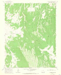
1964 Map of Barkelew Draw
USGS Topo · Published 1968About this map
Lilylands and the expansive Hamilton Mesa anchor this mid-1960s survey of the high plateau country in San Miguel County. The landscape is defined by a network of drainage systems, including the namesake Barkelew Draw and the more complex West Mud Springs Draw. While much of the eastern portion is protected within the Uncompahgre National Forest, the map also documents the modest human infrastructure of the era, such as the Basin Sch and various local resource extractions. Irrigation and water management are evident through features like the Two Fork Reservoir and several canals cut into the terrain. The presence of a Gravel Pit and scattered wells reflects the small-scale industrial and ranching activities that supported this community before more modern development reached the area.
Find a feature on this map
18 named features on this map. Tap any name to fly to it.
Don’t see what you’re looking for? This feature index may not catch every label — zoom into the map to look around manually.
Map Details
Editions of this 1964 Barkelew Draw Map
3 editions found
Other maps of this area

1916 · Paradox Valley
USGS Topo · 1:125,000

1922 · Paradox Valley
USGS Topo · 1:125,000

1956 · Cortez
USGS Topo · 1:250,000

1956 · Moab
USGS Topo · 1:250,000

1958 · Cortez
USGS Topo · 1:250,000

1959 · Cortez
USGS Topo · 1:250,000

1959 · Moab
USGS Topo · 1:250,000

1960 · Moab
USGS Topo · 1:250,000

1962 · Moab
USGS Topo · 1:250,000

1962 · Cortez
USGS Topo · 1:250,000