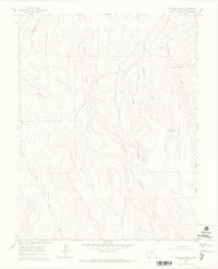
1964 Map of Barkelew Draw
USGS Topo · Published 1968About this map
Hamilton Mesa and the surrounding drainage systems of San Miguel County define this mid-century landscape. The map details an environment where early agricultural infrastructure, such as the Lilylands Canal and the South Lateral, snakes through complex terrain to manage water across the arid plateau. Educational and industrial markers of the 1960s appear through the Basin Sch and isolated Oil Well locations, indicating a sparse but active rural presence.
Find a feature on this map
21 named features on this map. Tap any name to fly to it.
Don’t see what you’re looking for? This feature index may not catch every label — zoom into the map to look around manually.
Map Details
Editions of this 1964 Barkelew Draw Map
3 editions found
Other maps of this area

1916 · Paradox Valley
USGS Topo · 1:125,000

1922 · Paradox Valley
USGS Topo · 1:125,000

1956 · Cortez
USGS Topo · 1:250,000

1956 · Moab
USGS Topo · 1:250,000

1958 · Cortez
USGS Topo · 1:250,000

1959 · Cortez
USGS Topo · 1:250,000

1959 · Moab
USGS Topo · 1:250,000

1960 · Moab
USGS Topo · 1:250,000

1962 · Moab
USGS Topo · 1:250,000

1962 · Cortez
USGS Topo · 1:250,000