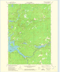
1972 Map of Barker Lake
USGS Topo · Published 1974About this map
The West Fork Chippewa River and East Fork Chippewa River converge in this northern Wisconsin landscape, feeding the expansive waters of Lake Chippewa. The map documents a significant intersection of jurisdictional boundaries, showing the eastern edge of the Lac Courte Oreilles Indian Reservation where it meets the Chequamegon National Forest. The hydrology of the region is central, controlled by the Winter Dam and characterized by intricate shorelines like those found at Moores Bay and Cranberry Narrows.
Find a feature on this map
34 named features on this map. Tap any name to fly to it.
Don’t see what you’re looking for? This feature index may not catch every label — zoom into the map to look around manually.
Map Details
Editions of this 1972 Barker Lake Map
2 editions found
Other maps of this area

1942 · Clam Lake
USGS Topo · 1:48,000

1943 · Namekagon Lake
USGS Topo · 1:48,000

1944 · Draper
USGS Topo · 1:48,000

1944 · Radisson
USGS Topo · 1:48,000

1945 · Namekagon Lake
USGS Topo · 1:48,000

1945 · Clam Lake
USGS Topo · 1:48,000

1947 · Draper
USGS Topo · 1:48,000

1949 · Radisson
USGS Topo · 1:48,000

1953 · Ashland
USGS Topo · 1:250,000

1953 · Rice Lake
USGS Topo · 1:250,000