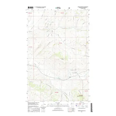
2017 Map of Barker Mountain
USGS Topo · Published 2017About this map
Anglin sits at the confluence of several canyon roads and creek valleys in this high-desert portion of Okanogan County. The terrain is defined by dramatic elevations, from the heights of Barker Mountain and Island Mtn down to the drainage basins of Bonaparte Creek and Siwash Creek. Toward the northern boundary, Fowler Field and Razor Lake provide localized landmarks within the complex topography of the T38N and T37N townships. To the southeast, the map reveals the boundary of the Okanogan National Forest, where the landscape transitions into protected timberlands. The dense network of named roads, such as Anglin Cemetery Rd and Howell Canyon Rd, provides a clear view of the area's rural infrastructure and accessibility to remote peaks and creek beds.
Find a feature on this map
53 named features on this map. Tap any name to fly to it.
Don’t see what you’re looking for? This feature index may not catch every label — zoom into the map to look around manually.
Map Details
Editions of this 2017 Barker Mountain Map
This is the sole edition of this map. No revisions or reprints were ever made.
Other maps of this area

1902 · Osoyoos
USGS Topo · 1:125,000

1904 · Osoyoos
USGS Topo · 1:125,000

1954 · Okanogan
USGS Topo · 1:250,000

1957 · Mt. Bonaparte
USGS Topo · 1:62,500

1957 · Tonasket
USGS Topo · 1:62,500

1957 · Oroville
USGS Topo · 1:62,500

1957 · Aeneas Valley
USGS Topo · 1:62,500

1958 · Okanogan
USGS Topo · 1:250,000
1980 · Keystone
USGS Topo · 1:24,000
1981 · Tonasket
USGS Topo · 1:24,000