
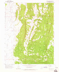
1964 Map of Barker Reservoir
USGS Topo · Published 1965About this map
High-altitude water management and livestock grazing define this portion of the Dixie National Forest in the mid-1960s. The landscape is dominated by the Aquarius Mountains and the extensive Griffin Top plateau, where a complex network of reservoirs and springs supports the local ecology and ranching operations. Significant water features include Barker Reservoir, Lower Barker Res, and the Joe Lay Reservoir, alongside smaller bodies like Velvet Lake and Flat Lake. The presence of White Ranch and named locations such as Holbys Bottom and Whites Cove points to the area's history of seasonal grazing. Transport across this terrain was primarily handled by a network of Pack Trails and Jeep Trails, linking remote points like The Gap and Dougherty Basin to the drainages of North Creek and Antimony Creek.
Find a feature on this map
40 named features on this map. Tap any name to fly to it.
Don’t see what you’re looking for? This feature index may not catch every label — zoom into the map to look around manually.
Map Details
Editions of this 1964 Barker Reservoir Map
This is the sole edition of this map. No revisions or reprints were ever made.
Other maps of this area

1885 · Fish Lake
USGS Topo · 1:250,000

1886 · Escalante
USGS Topo · 1:250,000

1896 · Fish Lake
USGS Topo · 1:250,000

1956 · Escalante
USGS Topo · 1:250,000

1956 · Salina
USGS Topo · 1:250,000

1960 · Escalante
USGS Topo · 1:250,000

1960 · Salina
USGS Topo · 1:250,000

1962 · Salina
USGS Topo · 1:250,000

1964 · Griffin Point
USGS Topo · 1:24,000
1964 · Grass Lakes
USGS Topo · 1:24,000