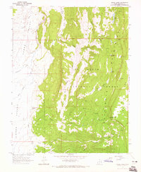
1964 Map of Grass Lakes
USGS Topo · Published 1965About this map
Johns Valley forms a broad western corridor on this mid-century topographic record, carved by the winding course of the East Fork Sevier River and its tributaries like Cottonwood Creek and Horse Creek. The landscape transitions sharply eastward into the dense verticality of Dixie National Forest, where the prominent Black Ridge separates the river valley from a high-altitude plateau.
Find a feature on this map
25 named features on this map. Tap any name to fly to it.
Don’t see what you’re looking for? This feature index may not catch every label — zoom into the map to look around manually.
Map Details
Editions of this 1964 Grass Lakes Map
This is the sole edition of this map. No revisions or reprints were ever made.
Other maps of this area

1885 · Beaver
USGS Topo · 1:250,000

1885 · Fish Lake
USGS Topo · 1:250,000

1886 · Kanab
USGS Topo · 1:250,000

1886 · Escalante
USGS Topo · 1:250,000

1896 · Fish Lake
USGS Topo · 1:250,000

1953 · Richfield
USGS Topo · 1:250,000

1953 · Cedar City
USGS Topo · 1:250,000

1956 · Escalante
USGS Topo · 1:250,000

1956 · Salina
USGS Topo · 1:250,000

1958 · Richfield
USGS Topo · 1:250,000