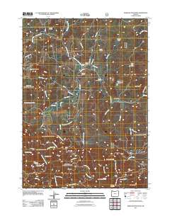
2011 Map of Barklow Mountain
USGS Topo · Published 2011About this map
The Sixes River and its numerous forks dominate this coastal mountain landscape in Coos County. The drainage network is dense, featuring the North Fork, Middle Fork, and South Fork, which converge as they flow through deep canyons and past high prairies. This topography supports several established holdings, including Avery Ranch, Dement Ranch, and Powers Ranch, reflecting a long-standing pattern of mountain ranching and resource extraction. Evidence of early settlement and industry is visible in the presence of the Blue Jay Mine near Star Mountain and several small burial grounds like Huckleberry Knoll Cemetery, Dement Cemetery, and Haines Cemetery. High-elevation landmarks such as Barklow Mountain, Granite Peak, and Sugarloaf Mountain define the horizon, while the Barklow Mountain Campground provides a modern point of access for this forest environment. The map also traces narrow access routes like Sixes River Rd and Old Eckley Rd as they follow the natural contours of the river valleys.
Find a feature on this map
56 named features on this map. Tap any name to fly to it.
Don’t see what you’re looking for? This feature index may not catch every label — zoom into the map to look around manually.
Map Details
Editions of this 2011 Barklow Mountain Map
This is the sole edition of this map. No revisions or reprints were ever made.
Other maps of this area

1899 · Port Orford
USGS Topo · 1:125,000

1903 · Port Orford
USGS Topo · 1:125,000

1954 · Coos Bay
USGS Topo · 1:250,000

1954 · Port Orford
USGS Topo · 1:62,500

1954 · Agness
USGS Topo · 1:62,500

1954 · Powers
USGS Topo · 1:62,500

1954 · Langlois
USGS Topo · 1:62,500

1958 · Coos Bay
USGS Topo · 1:250,000

1962 · Coos Bay
USGS Topo · 1:250,000
1985 · Calf Ranch Mtn
USGS Topo · 1:24,000