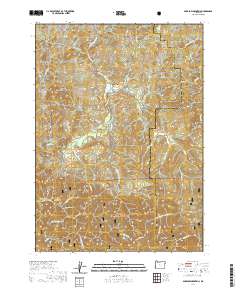
2020 Map of Barklow Mountain
USGS Topo · Published 2020About this map
Siskiyou National Forest land dominates this section of the Southern Oregon coast range, defined by the complex drainage systems of the Sixes River and its various branches. The landscape is characterized by prominent peaks like Barklow Mountain and Sugarloaf Mtn, with a network of forest service roads such as N Fork Sixes River Rd and Carlton Creek Rd providing access to the deep interior. Human presence is sparse but deeply rooted, evidenced by sites like Haines Cem and Huckleberry Knoll Cem. The convergence of Curry and Coos counties occurs in these high ridges, where features like Bear Pan Flat and Salt Lick Prairie suggest early uses of the mountain meadows. Small tributaries including Russian Mike Cr and Benson Cr feed the larger river system, which carves through named canyons like County Line Canyon.
Find a feature on this map
54 named features on this map. Tap any name to fly to it.
Don’t see what you’re looking for? This feature index may not catch every label — zoom into the map to look around manually.
Map Details
Editions of this 2020 Barklow Mountain Map
This is the sole edition of this map. No revisions or reprints were ever made.
Other maps of this area

1899 · Port Orford
USGS Topo · 1:125,000

1903 · Port Orford
USGS Topo · 1:125,000

1954 · Coos Bay
USGS Topo · 1:250,000

1954 · Port Orford
USGS Topo · 1:62,500

1954 · Agness
USGS Topo · 1:62,500

1954 · Powers
USGS Topo · 1:62,500

1954 · Langlois
USGS Topo · 1:62,500

1958 · Coos Bay
USGS Topo · 1:250,000

1962 · Coos Bay
USGS Topo · 1:250,000
1985 · Calf Ranch Mtn
USGS Topo · 1:24,000