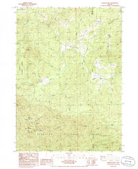
1986 Map of Barklow Mountain
USGS Topo · Published 1986About this map
Dement Ranch and Avery Ranch highlight the legacy of high-country livestock operations within the northern reaches of the Siskiyou National Forest during the mid-1980s. This drainage basin of the North Fork Sixes River and Middle Fork Sixes River is defined by a series of high-altitude openings such as Calf Ranch Prairie and High Prairie. The presence of a Cem near Bear Pan Flat suggests early homesteading roots deep in the backcountry, far from established towns. Surveyed by the Geological Survey with data from 1982, the map documents a landscape of steep timbered ridges including Camp Five Ridge and Bray Ridge, where logging activity is indicated by features like the Borrow Pit and several private access roads. The terrain is marked by distinctive local landmarks like Barklow Mtn and Russian Mike Creek, reflecting the rugged character of the Curry and Coos County line.
Find a feature on this map
54 named features on this map. Tap any name to fly to it.
Don’t see what you’re looking for? This feature index may not catch every label — zoom into the map to look around manually.
Map Details
Editions of this 1986 Barklow Mountain Map
This is the sole edition of this map. No revisions or reprints were ever made.
Other maps of this area

1899 · Port Orford
USGS Topo · 1:125,000

1903 · Port Orford
USGS Topo · 1:125,000

1954 · Coos Bay
USGS Topo · 1:250,000

1954 · Port Orford
USGS Topo · 1:62,500

1954 · Agness
USGS Topo · 1:62,500

1954 · Powers
USGS Topo · 1:62,500

1954 · Langlois
USGS Topo · 1:62,500

1958 · Coos Bay
USGS Topo · 1:250,000

1962 · Coos Bay
USGS Topo · 1:250,000
1985 · Calf Ranch Mtn
USGS Topo · 1:24,000