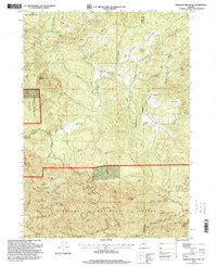
1996 Map of Barklow Mountain
USGS Topo · Published 1999About this map
Barklow Mountain and Salmon Mountain anchor this high-elevation landscape within the Siskiyou National Forest, where the complex headwaters of the Sixes River system converge. The topography is defined by the three primary branches of the river—the North Fork, Middle Fork, and South Fork—cutting deep drainage basins between major peaks. Local ranching history is evidenced by several remote outposts, including Dement Ranch, Avery Ranch, and Powers Ranch, often situated near unique mountain clearings like Carlton Prairie and Calf Ranch Prairie. A small Cem (cemetery) located near the Sixes River corridor provides a specific point of interest for genealogists tracking early inhabitants of this corner of Curry and Coos Counties. The map also records several family-named terrain features such as Mount Avery and Bray Mountain, alongside the notable Huckleberry Knoll.
Find a feature on this map
50 named features on this map. Tap any name to fly to it.
Don’t see what you’re looking for? This feature index may not catch every label — zoom into the map to look around manually.
Map Details
Editions of this 1996 Barklow Mountain Map
This is the sole edition of this map. No revisions or reprints were ever made.
Other maps of this area

1899 · Port Orford
USGS Topo · 1:125,000

1903 · Port Orford
USGS Topo · 1:125,000

1954 · Coos Bay
USGS Topo · 1:250,000

1954 · Port Orford
USGS Topo · 1:62,500

1954 · Agness
USGS Topo · 1:62,500

1954 · Powers
USGS Topo · 1:62,500

1954 · Langlois
USGS Topo · 1:62,500

1958 · Coos Bay
USGS Topo · 1:250,000

1962 · Coos Bay
USGS Topo · 1:250,000
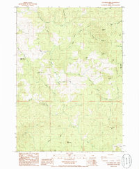
1985 · Calf Ranch Mtn
USGS Topo · 1:24,000