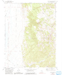
1971 Map of Barley Creek
USGS Topo · Published 1991About this map
Monitor Valley transitions into the high elevations of the Toiyabe National Forest in this central Nevada landscape. The terrain is defined by the massive plateau of Table Mountain and the deep incisions of Haystack Canyon and Mosquito Creek. Human presence is sparse, centered primarily on the Barley Creek Ranch situated along the drainage of Barley Creek.
Find a feature on this map
15 named features on this map. Tap any name to fly to it.
Don’t see what you’re looking for? This feature index may not catch every label — zoom into the map to look around manually.
Map Details
Editions of this 1971 Barley Creek Map
2 editions found
Other maps of this area

1956 · Tonopah
USGS Topo · 1:250,000

1959 · Tonopah
USGS Topo · 1:250,000

1962 · Tonopah
USGS Topo · 1:250,000

1971 · Belmont East
USGS Topo · 1:24,000

1971 · Corcoran Canyon
USGS Topo · 1:24,000

1971 · Barley Creek
USGS Topo · 1:24,000
1971 · Elkhorn Canyon
USGS Topo · 1:24,000

1971 · Mosquito Creek
USGS Topo · 1:24,000
1971 · Green Monster Canyon
USGS Topo · 1:24,000
1971 · Danville
USGS Topo · 1:24,000