
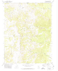
1971 Map of Mosquito Creek
USGS Topo · Published 1974About this map
Monitor Valley provides a stark contrast between flat basin lands and the rising elevation of Table Mountain in this early 1970s survey. The landscape is defined by the hydrologic network of Mosquito Creek and its tributaries, the North Fork and South Fork, which drain from the high reaches of the Toiyabe National Forest. Human presence is sparse and functional, centered on the Morgan Ranch and the distinctive Johnson Hole in the northern portion of the sheet. Geothermal activity is noted in the valley floor, specifically at a Well (Hot) near the base of the mountains. This era shows a primitive transportation network consisting of a single Jeep Trail and several miles of Pack Trail, reflecting the isolation of central Nevada before modern infrastructure changes. The map captures a moment when land use was primarily restricted to grazing and watershed management within the national forest boundaries.
Find a feature on this map
18 named features on this map. Tap any name to fly to it.
Don’t see what you’re looking for? This feature index may not catch every label — zoom into the map to look around manually.
Map Details
Editions of this 1971 Mosquito Creek Map
This is the sole edition of this map. No revisions or reprints were ever made.
Other maps of this area

1956 · Tonopah
USGS Topo · 1:250,000

1959 · Tonopah
USGS Topo · 1:250,000

1962 · Tonopah
USGS Topo · 1:250,000

1971 · Corcoran Canyon
USGS Topo · 1:24,000

1971 · Barley Creek
USGS Topo · 1:24,000
1971 · Green Monster Canyon
USGS Topo · 1:24,000
1971 · Dobbin Summit
USGS Topo · 1:24,000
1971 · Box Spring
USGS Topo · 1:24,000
1971 · Northumberland Pass
USGS Topo · 1:24,000
1971 · Danville
USGS Topo · 1:24,000