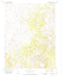
1971 Map of Dobbin Summit
USGS Topo · Published 1974About this map
Toiyabe National Forest forms the backdrop of this Nevada mountain landscape, dominated by the high elevations of the Monitor Range. Mapped in the early 1970s, the terrain is defined by a network of drainage systems including Black Rock Canyon and the headwaters of West Dobbin Creek. The area's high point at Dobbin Summit serves as a central landmark for the surrounding canyons and ridges, including Black Rock Mtn to the south.
Find a feature on this map
13 named features on this map. Tap any name to fly to it.
Don’t see what you’re looking for? This feature index may not catch every label — zoom into the map to look around manually.
Map Details
Editions of this 1971 Dobbin Summit Map
This is the sole edition of this map. No revisions or reprints were ever made.
Other maps of this area

1926 · Roberts Mountains
USGS Topo · 1:250,000

1929 · Roberts Mountains
USGS Topo · 1:250,000

1955 · Millett
USGS Topo · 1:250,000

1956 · Horse Heaven Mtn
USGS Topo · 1:62,500

1956 · Tonopah
USGS Topo · 1:250,000

1959 · Tonopah
USGS Topo · 1:250,000

1959 · Millett
USGS Topo · 1:250,000

1960 · Dianas Punch Bowl
USGS Topo · 1:62,500

1962 · Tonopah
USGS Topo · 1:250,000

1968 · Fish Springs
USGS Topo · 1:62,500