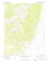
1971 Map of Northumberland Pass
USGS Topo · Published 1974About this map
The Toiyabe Range dominates this 1970s study of central Nevada, where the high-elevation terrain of the Toiyabe National Forest drops sharply into the expansive Monitor Valley. Industrial history is centered at the Northumberland Mine, a site marked by complex infrastructure including a Tailings Pond and several Ruins near the Northumberland Pass. This area was a focal point for mineral exploration, evidenced by various Prospects scattered across the slopes. The landscape is deeply incised by drainage systems such as Mill Canyon, Ella May Canyon, and West Northumberland Canyon. Significant landmarks for backcountry navigation include Mount Gooding and Mount Wilson, while lower elevations are reached via a network of Jeep Trails and unnamed trails that connect remote springs to the valley floor.
Find a feature on this map
25 named features on this map. Tap any name to fly to it.
Don’t see what you’re looking for? This feature index may not catch every label — zoom into the map to look around manually.
Map Details
Editions of this 1971 Northumberland Pass Map
This is the sole edition of this map. No revisions or reprints were ever made.
Other maps of this area

1926 · Roberts Mountains
USGS Topo · 1:250,000

1929 · Roberts Mountains
USGS Topo · 1:250,000

1955 · Millett
USGS Topo · 1:250,000

1956 · Tonopah
USGS Topo · 1:250,000

1959 · Tonopah
USGS Topo · 1:250,000

1959 · Millett
USGS Topo · 1:250,000

1960 · Dianas Punch Bowl
USGS Topo · 1:62,500

1960 · Wildcat Peak
USGS Topo · 1:62,500

1962 · Tonopah
USGS Topo · 1:250,000

1971 · Mosquito Creek
USGS Topo · 1:24,000