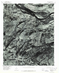
1976 Map of Barling
USGS Topo · Published 1978About this map
Fort Chaffee dominates the central landscape of this orthophotoquad, showing the extensive infrastructure of the military installation in the mid-1970s. The aerial imagery provides a clear view of the complex barracks and administrative grids south of Barling, offering a precise record of the base's footprint during this era. To the northwest, the expansion of Fort Smith and the community of Massard meet the southern banks of the Arkansas River, which is widened here by the Ozark Reservoir.
Find a feature on this map
7 named features on this map. Tap any name to fly to it.
Don’t see what you’re looking for? This feature index may not catch every label — zoom into the map to look around manually.
Map Details
Editions of this 1976 Barling Map
This is the sole edition of this map. No revisions or reprints were ever made.
Other maps of this area

1879 · Fort Smith
USGS Topo · 1:62,500

1887 · Van Buren
USGS Topo · 1:62,500

1887 · Greenwood
USGS Topo · 1:62,500

1890 · Fort Smith
USGS Topo · 1:125,000

1906 · Lavaca
USGS Topo · 1:62,500

1906 · Barber
USGS Topo · 1:62,500

1943 · Fort Smith
USGS Topo · 1:125,000

1946 · Fort Smith
USGS Topo · 1:250,000

1947 · Lavaca
USGS Topo · 1:62,500

1947 · Van Buren
USGS Topo · 1:62,500