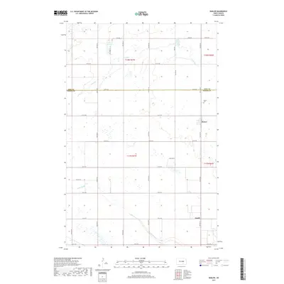
2017 Map of Barlow
USGS Topo · Published 2017About this map
Barlow sits at the heart of this North Dakota landscape, a small community defined by its proximity to the Barlow Cem and the surrounding agricultural grid of Foster Co and Eddy Co. This 2017 survey shows a region where the natural hydrology of the plains remains a dominant feature, characterized by numerous depressions and wetlands. The drainage patterns are clearly marked by Rosefield Slough in the north and the meandering Scotts Slough to the south, while Lake Claire provides a rare open water body. The map illustrates a meticulously planned township system, where local routes like 14th St NE and 66th Ave NE trace the boundaries of historic sections. Further south, the map records the location of Guptill, providing researchers with a contemporary look at the small clusters of settlement that continue to anchor this rural prairie environment.
Find a feature on this map
28 named features on this map. Tap any name to fly to it.
Don’t see what you’re looking for? This feature index may not catch every label — zoom into the map to look around manually.
Map Details
Editions of this 2017 Barlow Map
This is the sole edition of this map. No revisions or reprints were ever made.
Other maps of this area

1948 · New Rockford
USGS Topo · 1:62,500

1948 · Cathay
USGS Topo · 1:62,500

1948 · Carrington
USGS Topo · 1:62,500

1949 · Cathay SE
USGS Topo · 1:24,000

1949 · Munster
USGS Topo · 1:24,000

1950 · Carrington East
USGS Topo · 1:24,000

1950 · New Rockford
USGS Topo · 1:24,000

1950 · New Rockford NE
USGS Topo · 1:24,000
1950 · New Rockford SE
USGS Topo · 1:24,000

1950 · Barlow
USGS Topo · 1:24,000