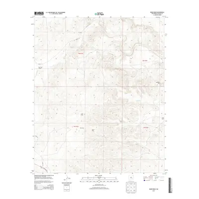
2013 Map of Barn Draw
USGS Topo · Published 2013About this map
Corn Ranch sits at the northern edge of this high-desert terrain in Chaves County, where a complex network of seasonal drainages and water management points defines the working landscape. The topography is dominated by the converging paths of Barn Draw and Camp Draw, which lead toward the serpentine course of Salt Cr. This 2013 survey illustrates the critical role of water infrastructure in the arid West, mapping isolated locations like Flat Tank, Ned Tank, and Trail Tank across the broken country. From the prominence of Haystack Mtn to the geological indentation of Devils Hole, the map reveals a remote area largely shaped by ranching and natural erosion, with Rock Tank Canyon cutting through the western sections. Primary access is provided by unpaved routes such as Verbana Rd and Draper Rd, tracing the movement of people and livestock through the basin.
Find a feature on this map
17 named features on this map. Tap any name to fly to it.
Don’t see what you’re looking for? This feature index may not catch every label — zoom into the map to look around manually.
Map Details
Editions of this 2013 Barn Draw Map
This is the sole edition of this map. No revisions or reprints were ever made.
Other maps of this area

1949 · Roswell North
USGS Topo · 1:24,000

1949 · Corn Ranch
USGS Topo · 1:24,000

1950 · Corn Ranch
USGS Topo · 1:24,000

1955 · Roswell
USGS Topo · 1:250,000

1958 · Roswell
USGS Topo · 1:250,000

1962 · Roswell
USGS Topo · 1:250,000
1962 · Roswell North
USGS Topo · 1:24,000

1962 · Horseshoe Bend
USGS Topo · 1:62,500

1962 · Rock House Canyon
USGS Topo · 1:24,000

1962 · Panther Hill
USGS Topo · 1:24,000