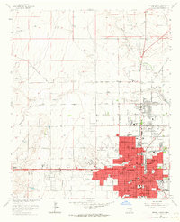
1962 Map of Roswell North
USGS Topo · Published 1964About this map
The city of Roswell serves as a dense urban core on the high plains of Chaves County, centered near the confluence of the Rio Hondo and the North Spring River. In the early 1960s, the community's character was defined by a mix of educational and institutional landmarks, notably the New Mexico Military Institute and the Poor Clares Monastery. Residential expansion is evident in the cluster of neighborhood schools such as Del Norte Sch, Military Heights Sch, and Parkview Sch.
Find a feature on this map
63 named features on this map. Tap any name to fly to it.
Don’t see what you’re looking for? This feature index may not catch every label — zoom into the map to look around manually.
Map Details
Editions of this 1962 Roswell North Map
3 editions found
Other maps of this area

1949 · Hondo Reservoir
USGS Topo · 1:24,000

1949 · Roswell North
USGS Topo · 1:24,000

1949 · Roswell South
USGS Topo · 1:24,000

1949 · Corn Ranch
USGS Topo · 1:24,000

1950 · Corn Ranch
USGS Topo · 1:24,000

1950 · South Spring
USGS Topo · 1:24,000

1950 · Bitter Lake
USGS Topo · 1:24,000

1955 · Roswell
USGS Topo · 1:250,000

1958 · Roswell
USGS Topo · 1:250,000

1962 · Roswell
USGS Topo · 1:250,000