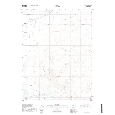
2019 Map of Barnesville
USGS Topo · Published 2019About this map
Matthews and Barnesville sit amidst a complex network of agricultural irrigation in Weld County, where the high plains meet the managed waters of the South Platte River. This 2019 survey documents the extensive water infrastructure essential to the region, including the Greeley Number 2 Canal, Empire Intake Canal, and Riverside Intake Canal. The landscape is defined by its rectilinear grid of county roads, such as Co RD 68 and Co RD 392, which connect these small settlements and surrounding farmsteads. Near the southern edge, the settlement of Kuner is situated along the river valley. A significant point for local genealogists is the Gerry Cem, located north of the river near Crow Cr. The map illustrates the 21st-century state of this working landscape, where traditional water rights and modern road systems continue to shape the community's layout.
Find a feature on this map
22 named features on this map. Tap any name to fly to it.
Don’t see what you’re looking for? This feature index may not catch every label — zoom into the map to look around manually.
Map Details
Editions of this 2019 Barnesville Map
This is the sole edition of this map. No revisions or reprints were ever made.
Other maps of this area

1902 · Greeley
USGS Topo · 1:125,000

1908 · Eaton
USGS Topo · 1:125,000

1910 · Eaton
USGS Topo · 1:125,000

1950 · Kersey
USGS Topo · 1:24,000

1950 · Barnesville
USGS Topo · 1:24,000

1950 · Valley View School
USGS Topo · 1:24,000

1950 · Hardin
USGS Topo · 1:24,000

1951 · Hardin
USGS Topo · 1:24,000
1951 · Valley View School
USGS Topo · 1:24,000

1951 · Point Of Rocks
USGS Topo · 1:24,000