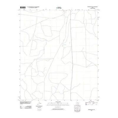
2010 Map of Barnhart SW
USGS Topo · Published 2010About this map
Spring Creek meanders through this portion of Crockett County, defining the drainage patterns of an arid landscape in West Texas. This 2010 topographic survey documents the remote road network of the ranchlands southwest of Barnhart, where long stretches of unpaved routes like Co Rd 311 and Co Rd 310 connect isolated property boundaries. The presence of Twin Lake provides a rare localized water feature in a region primarily defined by intermittent creek beds and vast open range. The map illustrates the minimal human footprint at the start of the 21st century, showing how modern county roads like Co Rd 302 and Co Rd 307 follow the natural contours of the high plains terrain, serving the essential needs of the local ranching economy.
Find a feature on this map
6 named features on this map. Tap any name to fly to it.
Don’t see what you’re looking for? This feature index may not catch every label — zoom into the map to look around manually.
Map Details
Editions of this 2010 Barnhart SW Map
This is the sole edition of this map. No revisions or reprints were ever made.
Other maps of this area

1920 · Big Lake
USGS Topo · 1:62,500

1920 · Barnhart
USGS Topo · 1:62,500

1922 · Big Lake
USGS Topo · 1:62,500

1922 · Barnhart
USGS Topo · 1:62,500

1954 · Sonora
USGS Topo · 1:250,000

1954 · San Angelo
USGS Topo · 1:250,000

1958 · Sonora
USGS Topo · 1:250,000

1958 · San Angelo
USGS Topo · 1:250,000

1965 · San Angelo
USGS Topo · 1:250,000
1967 · Schneeman Draw NE
USGS Topo · 1:24,000