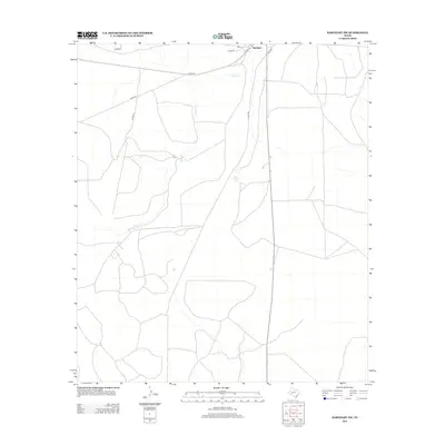
2013 Map of Barnhart SW
USGS Topo · Published 2013About this map
Barnhart anchors the northern edge of this West Texas landscape in the early twenty-first century, serving as a primary point of reference in an area dominated by wide ranchlands and intermittent waterways. The terrain is defined by the winding course of Spring Cr, which meanders across the central and northern sections of the map, and the isolated waters of Twin Lake. A network of rural county roads, including Co Rd-311 and Co Rd-312, provides the primary infrastructure for navigating this part of Crockett County. The mapping by the U.S. Geological Survey reflects the open, sparse nature of the region, where roads like Hinde Rd connect distant points across the scrubland. This survey captures the spatial relationship between the small settlement of Barnhart and the surrounding drainage patterns of the Edwards Plateau.
Find a feature on this map
9 named features on this map. Tap any name to fly to it.
Don’t see what you’re looking for? This feature index may not catch every label — zoom into the map to look around manually.
Map Details
Editions of this 2013 Barnhart SW Map
This is the sole edition of this map. No revisions or reprints were ever made.
Other maps of this area

1920 · Big Lake
USGS Topo · 1:62,500

1920 · Barnhart
USGS Topo · 1:62,500

1922 · Big Lake
USGS Topo · 1:62,500

1922 · Barnhart
USGS Topo · 1:62,500

1954 · Sonora
USGS Topo · 1:250,000

1954 · San Angelo
USGS Topo · 1:250,000

1958 · Sonora
USGS Topo · 1:250,000

1958 · San Angelo
USGS Topo · 1:250,000

1965 · San Angelo
USGS Topo · 1:250,000
1967 · Schneeman Draw NE
USGS Topo · 1:24,000