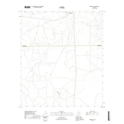
2019 Map of Barnhart SW
USGS Topo · Published 2019About this map
Barnhart anchors the northern edge of this West Texas landscape, positioned right at the boundary where Irion Co and Crockett Co meet. The terrain is defined by the ephemeral drainage of Spring Cr and the topographical depression of Buckhorn Draw to the south. Central to this area is Twin Lake, a localized water feature that stands out in an otherwise arid expanse of ranching country. The map traces a network of rural routes, including Co Rd 312 and Co Rd 302, which connect the scattered points of interest across the high plateau. This 2019 survey documents the enduring physical character of the Edwards Plateau region, highlighting how water sources like Spring Cr remain the primary landmarks in an open, sparsely settled environment.
Find a feature on this map
10 named features on this map. Tap any name to fly to it.
Don’t see what you’re looking for? This feature index may not catch every label — zoom into the map to look around manually.
Map Details
Editions of this 2019 Barnhart SW Map
This is the sole edition of this map. No revisions or reprints were ever made.
Other maps of this area

1920 · Big Lake
USGS Topo · 1:62,500

1920 · Barnhart
USGS Topo · 1:62,500

1922 · Big Lake
USGS Topo · 1:62,500

1922 · Barnhart
USGS Topo · 1:62,500

1954 · Sonora
USGS Topo · 1:250,000

1954 · San Angelo
USGS Topo · 1:250,000

1958 · Sonora
USGS Topo · 1:250,000

1958 · San Angelo
USGS Topo · 1:250,000

1965 · San Angelo
USGS Topo · 1:250,000
1967 · Schneeman Draw NE
USGS Topo · 1:24,000