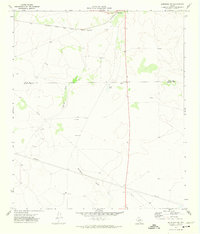
1971 Map of Barnhart SW
USGS Topo · Published 1974About this map
The Atchison Topeka and Santa Fe railroad cuts across the northern landscape of this West Texas territory, anchoring the small settlement of Barnhart. This ranching and resource-oriented region is defined by the ephemeral drainage of Spring Creek and the long expanse of Buckhorn Draw. Scattered evidence of early 1970s energy and material extraction is visible throughout the quadrangle, notably the Oil Wells and several Gravel Pits.
Find a feature on this map
18 named features on this map. Tap any name to fly to it.
Don’t see what you’re looking for? This feature index may not catch every label — zoom into the map to look around manually.
Map Details
Editions of this 1971 Barnhart SW Map
This is the sole edition of this map. No revisions or reprints were ever made.
Other maps of this area

1920 · Big Lake
USGS Topo · 1:62,500

1920 · Barnhart
USGS Topo · 1:62,500

1922 · Big Lake
USGS Topo · 1:62,500

1922 · Barnhart
USGS Topo · 1:62,500

1954 · Sonora
USGS Topo · 1:250,000

1954 · San Angelo
USGS Topo · 1:250,000

1958 · Sonora
USGS Topo · 1:250,000

1958 · San Angelo
USGS Topo · 1:250,000

1965 · San Angelo
USGS Topo · 1:250,000
1967 · Schneeman Draw NE
USGS Topo · 1:24,000