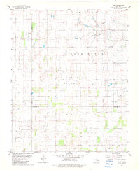
1982 Map of Barr
USGS Topo · Published 1983About this map
The Old Indian Treaty Boundary cuts horizontally across this central Oklahoma landscape, marking a historical division near the junction of Major, Kingfisher, and Garfield counties. In the early 1980s, the region was defined by a mix of agricultural sections and an expansive Oil and Gas Field, with a network of wells and a major Pipeline tracing through the townships of Sheridan, Washington, and Forest. Small rural hubs like Barr and Kennedy serve as the primary landmarks in this sparsely populated prairie country.
Find a feature on this map
18 named features on this map. Tap any name to fly to it.
Don’t see what you’re looking for? This feature index may not catch every label — zoom into the map to look around manually.
Map Details
Editions of this 1982 Barr Map
This is the sole edition of this map. No revisions or reprints were ever made.
Other maps of this area

1893 · Hennessey
USGS Topo · 1:62,500

1893 · Ames
USGS Topo · 1:62,500

1955 · Enid
USGS Topo · 1:250,000

1955 · Woodward
USGS Topo · 1:250,000

1956 · Ames
USGS Topo · 1:62,500

1956 · Hennessey
USGS Topo · 1:62,500

1956 · Enid
USGS Topo · 1:62,500

1956 · Ringwood
USGS Topo · 1:62,500

1958 · Enid
USGS Topo · 1:250,000

1958 · Woodward
USGS Topo · 1:250,000