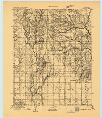
1893 Map of Hennessey
USGS Topo · Published 1893About this map
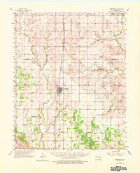
Hennessey serves as the central hub of this 1893 survey, positioned along the critical North-South corridor of the Chicago Rock Island and Pacific Railway. The map captures Oklahoma Territory in a period of early settlement, where the township structure of Hennessey and Columbia is beginning to take shape across the landscape. The geography is defined by the drainage systems of Skeleton Creek to the northeast and the wide basin of the Cimarron River to the south. Small outposts such as Buffalo Springs and Paris are documented at a time when the region was transitioning from open prairie to organized agricultural districts. The boundary line between Garfield County and Kingfisher County bisects the northern section of the map, illustrating the early administrative divisions established just years after the Land Run.
Find a feature on this map
14 named features on this map. Tap any name to fly to it.
Don’t see what you’re looking for? This feature index may not catch every label — zoom into the map to look around manually.
Map Details
Editions of this 1893 Hennessey Map
This is the sole edition of this map. No revisions or reprints were ever made.
Historical Maps of Hennessey Through Time
8 maps found