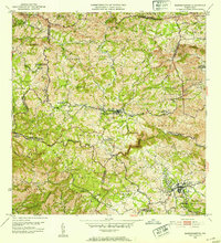
1953 Map of Barranquitas
USGS Topo · Published 1954About this map
Barranquitas and Aibonito anchor this mid-century mapping of the Puerto Rican interior, a landscape defined by the ridges of the Cordillera Central. The map documents a significant network of rural education, identifying numerous schools such as Escuela Segunda Unidad de Helechal and Escuela Segunda Unidad de Palo Hincado scattered throughout the barrios. The terrain is deeply incised by watercourses like the Río Usabón and Río Manatí, which have historically dictated the placement of settlements and agricultural holdings. Land use is captured through local landmarks like Hacienda Córcega and Casa Manresa, reflecting the area’s coffee and tobacco heritage. Prominent peaks including Cerro Farallón and Cerro Pulguillas rise above the dispersed population centers, illustrating the challenging topography that shaped the development of Pueblo Norte and Pueblo Sur.
Find a feature on this map
64 named features on this map. Tap any name to fly to it.
Don’t see what you’re looking for? This feature index may not catch every label — zoom into the map to look around manually.
Map Details
Editions of this 1953 Barranquitas Map
2 editions found
Other maps of this area

1945 · Rio Descalabrado
USGS Topo · 1:30,000

1946 · Coamo
USGS Topo · 1:30,000

1946 · Corozal
USGS Topo · 1:30,000

1946 · Barranquitas
USGS Topo · 1:30,000

1946 · Ciales
USGS Topo · 1:30,000

1946 · Cayey
USGS Topo · 1:30,000

1946 · Comerio
USGS Topo · 1:30,000

1946 · Naranjito
USGS Topo · 1:30,000

1946 · Orocovis
USGS Topo · 1:30,000

1947 · Corozal SO
USGS Topo · 1:10,000
Featured Places
- Aibonito
- Barranquitas
- Sector Los Pinos, Aibonito
- Parcelas de Helechal, Barranquitas
- Comunidad Bárbara Santiago, Barranquitas