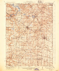
1923 Map of Barrington
USGS Topo · Published 1931About this map
Barrington and Palatine serve as the primary rail hubs for this section of northern Illinois, situated at the crossroads of the Chicago and Northwestern and the Elgin Joliet and Eastern railroads. The landscape is a dense network of early rural education and local faith, characterized by dozens of numbered and family-named schoolhouses such as Rawson Bridge School, Bucklin School, and Meyers School, alongside landmarks like the Bohemian Church. To the north, the terrain transitions into a lake-district character around Lake Zurich, Honey Lake, and Grassy Lake, which supported early recreation spots like the Speeck Resort. The survey illustrates a pre-suburban era where large tracts like the Cook County Forest Preserve began to be set aside, while agricultural life was still defined by small hamlets such as Quentins Corners and Sutton.
Find a feature on this map
94 named features on this map. Tap any name to fly to it.
Don’t see what you’re looking for? This feature index may not catch every label — zoom into the map to look around manually.
Map Details
Editions of this 1923 Barrington Map
4 editions found

Other maps of this area

1891 · Riverside
USGS Topo · 1:62,500

1893 · Riverside
USGS Topo · 1:62,500

1900 · Riverside
USGS Topo · 1:62,500

1900 · Highwood
USGS Topo · 1:62,500

1901 · Riverside
USGS Topo · 1:62,500

1906 · Waukegan
USGS Topo · 1:62,500

1908 · Wheaton
USGS Topo · 1:62,500

1908 · Waukegan
USGS Topo · 1:62,500

1920 · Grays Lake
USGS Topo · 1:62,500

1923 · Grays Lake
USGS Topo · 1:62,500