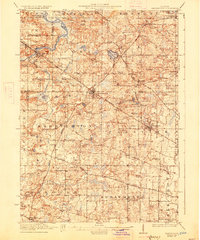
1923 Map of Barrington
USGS Topo · Published 1927About this map
Barrington and Palatine serve as the primary hubs of this landscape during the early 1920s, a period when the region's agricultural roots began to integrate with the expanding Chicago and Northwestern rail network. This survey reveals a high density of one-room schoolhouses, such as Kelsey School and Hager School, and specialized community centers like the Bohemian Church and St Johns Church, illustrating the localized nature of social life before widespread modernization. To the north, the area around Lake Zurich and Slocum Lake showcases the early recreational and residential appeal of the kettle lake topography. The map also documents the early footprint of the Cook County Forest Preserve, including Camp Reinberg, indicating a deliberate effort to conserve open space even as small settlements like Quentins Corners and Sutton remained active rural crossroads.
Find a feature on this map
98 named features on this map. Tap any name to fly to it.
Don’t see what you’re looking for? This feature index may not catch every label — zoom into the map to look around manually.
Map Details
Editions of this 1923 Barrington Map
4 editions found

Other maps of this area

1891 · Riverside
USGS Topo · 1:62,500

1893 · Riverside
USGS Topo · 1:62,500

1900 · Riverside
USGS Topo · 1:62,500

1900 · Highwood
USGS Topo · 1:62,500

1901 · Riverside
USGS Topo · 1:62,500

1906 · Waukegan
USGS Topo · 1:62,500

1908 · Wheaton
USGS Topo · 1:62,500

1908 · Waukegan
USGS Topo · 1:62,500

1920 · Grays Lake
USGS Topo · 1:62,500

1923 · Grays Lake
USGS Topo · 1:62,500