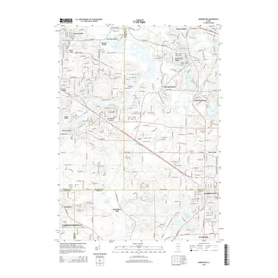
2015 Map of Barrington
USGS Topo · Published 2015About this map
The Fox River corridor defines the western reaches of this region, where the steep terrain of Ski Hill and the winding Flint Creek navigate between several lakeside communities. Established burial grounds including Windridge Cemetery and Evergreen Cemetery offer valuable points of interest for those tracking local lineages in Barrington and Cary. The landscape is dominated by glacial topography, featuring numerous bodies of water such as Tower Lake, Honey Lake, and Goose Lake, often surrounded by modern suburban development like Barrington Hills and North Barrington. The Metra rail line runs northwest to southeast, cutting through the heart of Fox River Grove and Barrington. This 2015 layout documents the intersection of three counties and the preservation of open spaces like Grassy Lake amidst the continued residential expansion of the Northwest Suburbs.
Find a feature on this map
85 named features on this map. Tap any name to fly to it.
Don’t see what you’re looking for? This feature index may not catch every label — zoom into the map to look around manually.
Map Details
Editions of this 2015 Barrington Map
This is the sole edition of this map. No revisions or reprints were ever made.
Other maps of this area

1920 · Grays Lake
USGS Topo · 1:62,500

1923 · Grays Lake
USGS Topo · 1:62,500

1923 · Barrington
USGS Topo · 1:62,500

1925 · Elgin
USGS Topo · 1:62,500

1926 · Mc Henry
USGS Topo · 1:62,500

1935 · Barrington
USGS Topo · 1:62,500

1940 · Elgin
USGS Topo · 1:62,500

1944 · McHenry
USGS Topo · 1:62,500
1953 · Palatine
USGS Topo · 1:24,000

1954 · Rockford
USGS Topo · 1:250,000