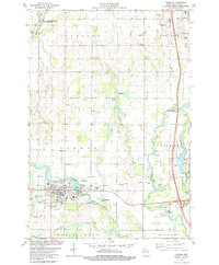
1978 Map of Barron
USGS Topo · Published 1979About this map
The Barron city center sits at the confluence of the Yellow River and Quaderer Creek, serving as a localized hub for the surrounding dairy and agricultural landscape in the late 1970s. The town's layout is defined by the Soo Line railroad tracks and essential community landmarks like the Hosp, High Sch, and the County Museum. The map reveals a transition from the urban grid of Barron to the rural townships of Stanfold and Stanley, where smaller cultural sites like the Swede Cem and Abundant Life Ch mark the rural social fabric.
Find a feature on this map
47 named features on this map. Tap any name to fly to it.
Don’t see what you’re looking for? This feature index may not catch every label — zoom into the map to look around manually.
Map Details
Editions of this 1978 Barron Map
This is the sole edition of this map. No revisions or reprints were ever made.
Other maps of this area

1949 · Rice Lake
USGS Topo · 1:48,000

1951 · Shell Lake
USGS Topo · 1:48,000

1951 · Rice Lake
USGS Topo · 1:48,000

1951 · Chetek
USGS Topo · 1:62,500

1951 · Barron
USGS Topo · 1:62,500

1953 · Rice Lake
USGS Topo · 1:250,000

1959 · Rice Lake
USGS Topo · 1:250,000

1965 · Rice Lake
USGS Topo · 1:62,500

1965 · Shell Lake
USGS Topo · 1:62,500
1978 · Poskin
USGS Topo · 1:24,000