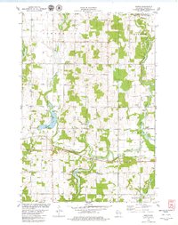
1978 Map of Poskin
USGS Topo · Published 1979About this map
Poskin serves as the focal point of this late-1970s landscape, situated along the Soo Line railroad and the Vermillion River. The area is characterized by its glacial hydrology, featuring numerous water bodies like Poskin Lake and Crystal Bay Lake, as well as the headwaters of Quaderer Creek and the Hay River. The rural character is further evidenced by several established community hubs, including the Paul Revere Community Center and a series of township cemeteries such as St Lukes Cem and Lutheran Cem. The northern section is dominated by the Yellow River State Public Fishery Area, underscoring the importance of conservation and natural resources in Barron County. This survey provides a clear look at the agricultural and transit patterns of the era, where small settlements were tightly linked by rail and river networks.
Find a feature on this map
24 named features on this map. Tap any name to fly to it.
Don’t see what you’re looking for? This feature index may not catch every label — zoom into the map to look around manually.
Map Details
Editions of this 1978 Poskin Map
This is the sole edition of this map. No revisions or reprints were ever made.
Other maps of this area

1950 · Turtle Lake
USGS Topo · 1:62,500

1951 · Cumberland
USGS Topo · 1:48,000

1951 · Shell Lake
USGS Topo · 1:48,000

1951 · Barron
USGS Topo · 1:62,500

1952 · Turtle Lake
USGS Topo · 1:62,500

1953 · Rice Lake
USGS Topo · 1:250,000

1953 · Stillwater
USGS Topo · 1:250,000

1955 · Stillwater
USGS Topo · 1:250,000

1956 · Cumberland
USGS Topo · 1:62,500

1958 · Stillwater
USGS Topo · 1:250,000