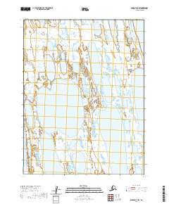
2020 Map of Barrow A-4 SW
USGS Topo · Published 2020About this map
Sukok Lake and Evrulivik Lake anchor this remote Arctic landscape on the North Slope, where the terrain is dominated by a complex network of thaw lakes and wetlands. The map illustrates a section of the coastal plain characterized by these distinctive water bodies, which are essential features of the regional hydrography. The inclusion of Kimouksik Lake in the northeast corner further highlights the high density of these thermokarst features. The vast system of public land divisions, including t20n r19w and t20n r18w, provides a structured grid over an otherwise fluid and shifting watery environment, reflecting the precision of modern geodetic surveys in documenting this isolated wilderness.
Find a feature on this map
8 named features on this map. Tap any name to fly to it.
Don’t see what you’re looking for? This feature index may not catch every label — zoom into the map to look around manually.
Map Details
Editions of this 2020 Barrow A-4 SW Map
This is the sole edition of this map. No revisions or reprints were ever made.
Other maps of this area

1945 · Barrow
USGS Topo · 1:250,000

1949 · Barrow
USGS Topo · 1:250,000

1951 · Meade River
USGS Topo · 1:250,000

1955 · Barrow
USGS Topo · 1:250,000

1955 · Meade River
USGS Topo · 1:250,000

1955 · Barrow A-4
USGS Topo · 1:63,360

1955 · Barrow A-5
USGS Topo · 1:63,360

1955 · Meade River D-2
USGS Topo · 1:63,360
1955 · Meade River D-1
USGS Topo · 1:63,360
1962 · Meade River D-2
USGS Topo · 1:50,000