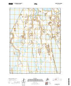
2020 Map of Barrow A-5 SE
USGS Topo · Published 2020About this map
The Chukchi Sea coastline defines the western edge of this Arctic landscape, where the terrestrial environment is dominated by a complex network of thaw lakes and narrow drainage systems. Goose Point stands as a prominent coastal landmark, marking the transition from the marine environment to the vast tundra. Moving inland, the meandering path of the Walakpa River and its tributary Singaruak cut through the permafrost-underlain terrain, eventually reaching the significant expanse of Kilusiktok Lake in the south. The 2020 data reflects a modern period of topographic record-keeping in the North Slope Borough, capturing the intricate hydrography of the Alaskan coastal plain before seasonal shifts further alter these sensitive shorelines and seasonal water bodies.
Find a feature on this map
11 named features on this map. Tap any name to fly to it.
Don’t see what you’re looking for? This feature index may not catch every label — zoom into the map to look around manually.
Map Details
Editions of this 2020 Barrow A-5 SE Map
This is the sole edition of this map. No revisions or reprints were ever made.
Other maps of this area

1945 · Barrow
USGS Topo · 1:250,000

1949 · Barrow
USGS Topo · 1:250,000

1951 · Meade River
USGS Topo · 1:250,000

1955 · Barrow
USGS Topo · 1:250,000

1955 · Meade River
USGS Topo · 1:250,000

1955 · Barrow A-4
USGS Topo · 1:63,360

1955 · Barrow A-5
USGS Topo · 1:63,360

1955 · Meade River D-2
USGS Topo · 1:63,360

1955 · Meade River D-3
USGS Topo · 1:63,360
1962 · Meade River D-3
USGS Topo · 1:50,000