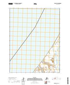
2020 Map of Barrow A-5 SW
USGS Topo · Published 2020About this map
The Chukchi Sea dominates this coastal Arctic landscape, occupying the vast majority of the survey area. Located on the northernmost edge of the continent, the map illustrates a sparse, marine-dominated environment where the shoreline only emerges in the southeastern corner. This coastal margin is characterized by low-lying wetlands and complex hydrography typical of the North Slope, though no named settlements or inland landmarks appear on this specific sheet. The map is primarily structured by the Public Land Survey System grid, featuring segments of Townships 19 through 21 North and Ranges 20 through 21 West. It serves as a stark document of the remote maritime boundary where the Alaskan tundra meets the Arctic waters.
Find a feature on this map
6 named features on this map. Tap any name to fly to it.
Don’t see what you’re looking for? This feature index may not catch every label — zoom into the map to look around manually.
Map Details
Editions of this 2020 Barrow A-5 SW Map
This is the sole edition of this map. No revisions or reprints were ever made.
Other maps of this area

1945 · Barrow
USGS Topo · 1:250,000

1949 · Barrow
USGS Topo · 1:250,000

1951 · Meade River
USGS Topo · 1:250,000

1955 · Barrow
USGS Topo · 1:250,000

1955 · Meade River
USGS Topo · 1:250,000

1955 · Barrow A-5
USGS Topo · 1:63,360

1955 · Meade River D-2
USGS Topo · 1:63,360

1955 · Meade River D-3
USGS Topo · 1:63,360
1962 · Meade River D-3
USGS Topo · 1:50,000
1962 · Meade River D-2
USGS Topo · 1:50,000