
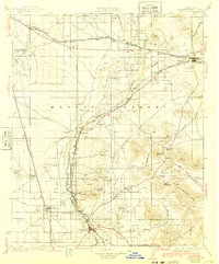
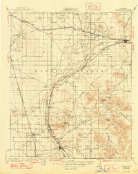
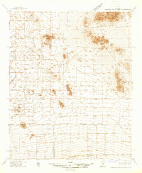
1934 Map of Barstow
USGS Topo · Published 1934About this map
The Mojave River serves as the central artery for this high desert landscape, dictating the placement of the Atchison Topeka and Santa Fe railroad and the early road network. In this era, Barstow and Victorville emerge as the primary hubs connected by U S Highway No 66, which follows the river's path through the Lower Narrows and Upper Narrows. The map reveals a transition from traditional desert mining to early twentieth-century settlement, with active operations like the Western States Mine, Sidewinder Mine, and Red Raven Mine scattered across the surrounding peaks.
Find a feature on this map
53 named features on this map. Tap any name to fly to it.
Don’t see what you’re looking for? This feature index may not catch every label — zoom into the map to look around manually.
Map Details
Editions of this 1934 Barstow Map
3 editions found
Other maps of this area

1901 · Southern California Sheet No. 1
USGS Topo · 1:250,000

1902 · Deep Creek
USGS Topo · 1:62,500

1902 · Hesperia
USGS Topo · 1:62,500

1902 · San Gorgonio
USGS Topo · 1:125,000

1903 · San Antonio
USGS Topo · 1:62,500

1904 · Southern California Sheet No. 1
USGS Topo · 1:250,000

1915 · Searles Lake
USGS Topo · 1:250,000

1932 · Barstow
USGS Topo · 1:125,000

1933 · Avawatz Mountains
USGS Topo · 1:250,000
1937 · Shadow Mountains
USGS Topo · 1:48,000