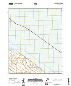
2018 Map of Barter Island A-3 SW
USGS Topo · Published 2018About this map
Beaufort Sea waters dominate the northern reaches of this coastal survey, where the Arctic shoreline meets a network of low-lying wetlands. The landscape is defined by the transition from the open sea into the protected waters of Pokok Lagoon, a significant coastal feature that buffers the mainland from the pack ice and waves of the north. Inland, the hydrology is shaped by the wandering path of Pokok Cr, which drains into the lagoon across a flat coastal plain. This 2018 data reflects the modern shoreline and township boundaries of t8n r37e and t8n r38e, documenting the intersection of sea and land in a region where shifting ice and seasonal melt dictate the character of the terrain.
Find a feature on this map
5 named features on this map. Tap any name to fly to it.
Don’t see what you’re looking for? This feature index may not catch every label — zoom into the map to look around manually.
Map Details
Editions of this 2018 Barter Island A-3 SW Map
This is the sole edition of this map. No revisions or reprints were ever made.
Other maps of this area

1951 · Barter Island
USGS Topo · 1:250,000

1951 · Demarcation Point
USGS Topo · 1:250,000

1955 · Demarcation Point
USGS Topo · 1:250,000

1955 · Demarcation Point D-3
USGS Topo · 1:63,360

1955 · Barter Island A-4
USGS Topo · 1:63,360
1955 · Barter Island A-3
USGS Topo · 1:63,360

1955 · Demarcation Point D-4
USGS Topo · 1:63,360

1959 · Barter Island
USGS Topo · 1:250,000

1962 · Demarcation Point D-3
USGS Topo · 1:50,000

1964 · Demarcation Point
USGS Topo · 1:250,000