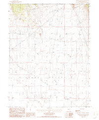
1986 Map of Bartine Ranch NE
USGS Topo · Published 1986About this map
Old Pony Express Trail cuts across the northern reaches of this landscape, marking a path through the high desert of central Nevada in the mid-1980s. The terrain is dominated by the wide expanse of Kobe Valley, where seasonal drainage is managed by several stock tanks and natural water sources like Mud Spring. The drainage of Roberts Creek flows southward through the basin, providing a focal point for the cattle ranching operations that characterize the area. Near the historic trail, scattered Prospects indicate the region's enduring connection to mineral exploration. This survey provides a clear view of the ranching infrastructure and historical transportation corridors in Eureka County during a period of transition in the Great Basin.
Find a feature on this map
10 named features on this map. Tap any name to fly to it.
Don’t see what you’re looking for? This feature index may not catch every label — zoom into the map to look around manually.
Map Details
Editions of this 1986 Bartine Ranch NE Map
This is the sole edition of this map. No revisions or reprints were ever made.
Other maps of this area

1926 · Roberts Mountains
USGS Topo · 1:250,000

1929 · Roberts Mountains
USGS Topo · 1:250,000

1949 · Garden Valley
USGS Topo · 1:62,500

1949 · Roberts Creek Mtn
USGS Topo · 1:62,500

1951 · Roberts Creek Mtn
USGS Topo · 1:62,500

1951 · Garden Valley
USGS Topo · 1:62,500

1955 · Millett
USGS Topo · 1:250,000

1956 · Bartine Ranch
USGS Topo · 1:62,500

1956 · Whistler Mtn
USGS Topo · 1:62,500

1959 · Millett
USGS Topo · 1:250,000