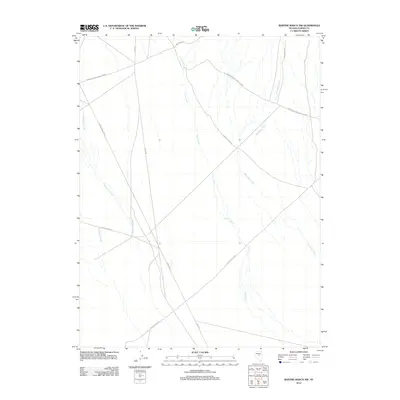
2012 Map of Bartine Ranch NW
USGS Topo · Published 2012About this map
Pony Express Trl cuts across this high-desert basin in Eureka County, marking a historic corridor of western movement through central Nevada. The 2012 landscape is characterized by a network of ranch-access routes and seasonal watercourses, reflecting the area's continued use for livestock grazing. Several named ranch roads, including Roberts Creek-Santa Fe Rnch, Santa Fe Ranch Rd, and Ferguson Rnch, connect various grazing parcels across the valley floor. Water management and natural drainage are evident through the paths of Coils Creek, Rutabaga Creek, and Underwood Creek, which provide vital resources in an otherwise arid environment. The map details the intersection of historic transit lines and modern rural infrastructure, such as Gold Bar Rd and the route from 3 Bar to Lone Mtn.
Find a feature on this map
11 named features on this map. Tap any name to fly to it.
Don’t see what you’re looking for? This feature index may not catch every label — zoom into the map to look around manually.
Map Details
Editions of this 2012 Bartine Ranch NW Map
This is the sole edition of this map. No revisions or reprints were ever made.
Other maps of this area

1926 · Roberts Mountains
USGS Topo · 1:250,000

1929 · Roberts Mountains
USGS Topo · 1:250,000

1949 · Roberts Creek Mtn
USGS Topo · 1:62,500

1951 · Roberts Creek Mtn
USGS Topo · 1:62,500

1955 · Millett
USGS Topo · 1:250,000

1956 · Bartine Ranch
USGS Topo · 1:62,500

1956 · Walti Hot Springs
USGS Topo · 1:62,500

1956 · Ackerman Canyon
USGS Topo · 1:62,500

1959 · Millett
USGS Topo · 1:250,000

1979 · Simpson Park Mtns
USGS Topo · 1:100,000