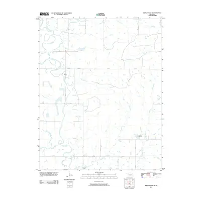
2010 Map of Bartlesville SE
USGS Topo · Published 2010About this map
The Caney River meanders across this rural Oklahoma landscape, joined by a dense network of tributaries including Hogshooter Creek, Fourmile Creek, and Curl Creek. This early 21st-century survey documents the transition from winding river valleys to the organized grid of county roads that define modern Rogers County. Local history is anchored by Tyner Cemetery near the riverbanks and Buck Creek Cemetery to the south, serving as vital landmarks for genealogists and researchers tracing family ties to the area. The hydrology is further defined by the Wagoner Lake Dam on Rabb Creek, showing how water management has shaped the local topography. This map reveals a landscape dominated by agricultural sections and small water bodies like Timberlake Creek and Stick Creek, illustrating the intersection of natural drainage and human settlement patterns in the Sooner State.
Find a feature on this map
33 named features on this map. Tap any name to fly to it.
Don’t see what you’re looking for? This feature index may not catch every label — zoom into the map to look around manually.
Map Details
Editions of this 2010 Bartlesville SE Map
This is the sole edition of this map. No revisions or reprints were ever made.
Other maps of this area

1901 · Claremore
USGS Topo · 1:125,000

1901 · Nowata
USGS Topo · 1:125,000

1914 · Nowata
USGS Topo · 1:125,000

1914 · Claremore
USGS Topo · 1:125,000

1916 · Claremore
USGS Topo · 1:125,000

1954 · Tulsa
USGS Topo · 1:250,000

1958 · Tulsa
USGS Topo · 1:250,000

1959 · Collinsville NE
USGS Topo · 1:24,000
1959 · Vera
USGS Topo · 1:24,000

1963 · Tulsa
USGS Topo · 1:250,000