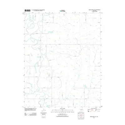
2012 Map of Bartlesville SE
USGS Topo · Published 2012About this map
The Caney River carves a winding path through this portion of Rogers County, defining a landscape dominated by riparian corridors and a grid of rural county roads. A primary point of interest for genealogists and local historians is the Tyner Cem, situated on a gentle rise east of the river. The area is defined by its extensive drainage network, where numerous tributaries such as Hogshooter Cr, Timberlake Cr, and Double Cr feed into the main river channel. This 2012 survey reveals a section of Oklahoma where the land is strictly partitioned by roads like N 4030 RD and W 3000 RD, reflecting the persistent section-line development pattern of the region. Small water bodies and ponds are scattered throughout the quadrangle, particularly along Rabb Cr and Buck Cr in the eastern half of the sheet.
Find a feature on this map
37 named features on this map. Tap any name to fly to it.
Don’t see what you’re looking for? This feature index may not catch every label — zoom into the map to look around manually.
Map Details
Editions of this 2012 Bartlesville SE Map
This is the sole edition of this map. No revisions or reprints were ever made.
Other maps of this area

1901 · Claremore
USGS Topo · 1:125,000

1901 · Nowata
USGS Topo · 1:125,000

1914 · Nowata
USGS Topo · 1:125,000

1914 · Claremore
USGS Topo · 1:125,000

1916 · Claremore
USGS Topo · 1:125,000

1954 · Tulsa
USGS Topo · 1:250,000

1958 · Tulsa
USGS Topo · 1:250,000

1959 · Collinsville NE
USGS Topo · 1:24,000
1959 · Vera
USGS Topo · 1:24,000

1963 · Tulsa
USGS Topo · 1:250,000