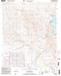
2004 Map of Bartlett Dam
USGS Topo · Published 2007About this map
The Verde River carves a deep path through the heart of the Tonto National Forest in this 2004 revision of the Maricopa County landscape. The mapping centers on the vital water infrastructure of the Bartlett Dam, which impounds the Bartlett Reservoir, a significant regional landmark for water management and recreation. The interface between the water and the arid desert terrain is marked by specific access points like the Jojoba Boating Site and the Sheriff Aid Station Boating Ramp, alongside the small riverside community of Riverside.
Find a feature on this map
25 named features on this map. Tap any name to fly to it.
Don’t see what you’re looking for? This feature index may not catch every label — zoom into the map to look around manually.
Map Details
Editions of this 2004 Bartlett Dam Map
This is the sole edition of this map. No revisions or reprints were ever made.
Other maps of this area

1904 · Camelback
USGS Topo · 1:62,500

1904 · Ft. McDowell
USGS Topo · 1:62,500

1906 · Camelsback
USGS Topo · 1:62,500

1906 · Ft. McDowell
USGS Topo · 1:62,500

1930 · Cave Creek
USGS Topo · 1:125,000

1939 · Cave Creek
USGS Topo · 1:125,000

1954 · Mesa
USGS Topo · 1:250,000

1957 · Mesa
USGS Topo · 1:250,000

1958 · Mesa
USGS Topo · 1:250,000

1960 · Mesa
USGS Topo · 1:250,000