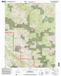
1996 Map of Bartlett Mountain
USGS Topo · Published 2001About this map
Mendocino National Forest dominates this California landscape, where high ridge lines and deep creek drainages define the transition between the coastal mountains and the interior. The survey captures the area in the late 1990s, anchored by the settlement of Nice along the Lakeview Hwy at the southern edge. The topography is marked by significant elevation changes, from the prominent Bartlett Mountain and the High Glade Lookout to the distinct meadow-like openings of Carter Glades and Wyman Glade. The network of watercourses, including Clover Creek and Middle Creek, illustrates a complex watershed that historically supported ranching at sites like Jones Ranch. The inclusion of family-named landmarks like Ladder Ridge and isolated points such as Red Rock provides essential context for researchers tracing the historical footprint of land use and fire observation in Lake County.
Find a feature on this map
45 named features on this map. Tap any name to fly to it.
Don’t see what you’re looking for? This feature index may not catch every label — zoom into the map to look around manually.
Map Details
Editions of this 1996 Bartlett Mountain Map
This is the sole edition of this map. No revisions or reprints were ever made.
Other maps of this area

1922 · Hullville
USGS Topo · 1:62,500

1924 · Bartlett Springs
USGS Topo · 1:62,500

1938 · Lakeport
USGS Topo · 1:62,500

1942 · Bartlett Springs
USGS Topo · 1:62,500

1944 · Bartlett Springs
USGS Topo · 1:62,500

1951 · Lake Pillsbury
USGS Topo · 1:62,500

1951 · Lakeport
USGS Topo · 1:62,500

1951 · Stonyford
USGS Topo · 1:62,500

1957 · Ukiah
USGS Topo · 1:250,000

1958 · Clearlake Oaks
USGS Topo · 1:24,000