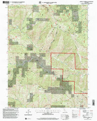
1996 Map of Bartlett Springs
USGS Topo · Published 2001About this map
Bartlett Springs and its neighboring mineral spring sites anchor this mid-1990s look at the eastern edge of Mendocino National Forest. The landscape is defined by the steep drainage basins of the Rice Fork and North Fork Cache Creek, where complex terrain features like Spanish Ridge and Soapstone Ridge divide the wilderness. For local historians, the presence of the Bartlett Cemetery and the Pacific Ridge FS Station provides evidence of the area's long-standing human activity within the national forest system. The map details a network of 4WD tracks and trails that reach into isolated flats and glades, including Wyman Flat, Johnson Glades, and White Ranch Glades. These scattered clearings among the high ridges like Pine Mountain and Ruppert Point illustrate the historical land use patterns of high-elevation ranching and forestry at the turn of the 21st century.
Find a feature on this map
60 named features on this map. Tap any name to fly to it.
Don’t see what you’re looking for? This feature index may not catch every label — zoom into the map to look around manually.
Map Details
Editions of this 1996 Bartlett Springs Map
This is the sole edition of this map. No revisions or reprints were ever made.
Other maps of this area

1922 · Hullville
USGS Topo · 1:62,500

1924 · Bartlett Springs
USGS Topo · 1:62,500

1938 · Lakeport
USGS Topo · 1:62,500

1942 · Bartlett Springs
USGS Topo · 1:62,500

1944 · Bartlett Springs
USGS Topo · 1:62,500

1951 · Lake Pillsbury
USGS Topo · 1:62,500

1951 · Lakeport
USGS Topo · 1:62,500

1951 · Stonyford
USGS Topo · 1:62,500

1957 · Ukiah
USGS Topo · 1:250,000

1958 · Clearlake Oaks
USGS Topo · 1:24,000