
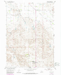
1954 Map of Bartlett
USGS Topo · Published 1956About this map
Bartlett serves as the primary focal point of this mid-century Wheeler County survey, showing the town's layout during the postwar era. The surrounding landscape is defined by the transition from the distinct drainage of Beaver Creek and the low-lying Buffalo Flats to the more complex, undulating terrain simply labeled Buffalo. This topography is marked by a high density of water-management features essential for ranching and agriculture in the Nebraska Sandhills, including numerous Windmill sites and a Flowing Well located near the Headquarters Sch.
Find a feature on this map
13 named features on this map. Tap any name to fly to it.
Don’t see what you’re looking for? This feature index may not catch every label — zoom into the map to look around manually.
Map Details
Editions of this 1954 Bartlett Map
2 editions found
Other maps of this area

1954 · Bartlett NW
USGS Topo · 1:24,000

1954 · Bartlett SE
USGS Topo · 1:24,000

1954 · Ericson
USGS Topo · 1:24,000

1955 · Broken Bow
USGS Topo · 1:250,000

1955 · O'Neill
USGS Topo · 1:250,000

1956 · Broken Bow
USGS Topo · 1:250,000

1959 · O'Neill
USGS Topo · 1:250,000

1960 · Spalding 2 SW
USGS Topo · 1:24,000

1960 · Spalding 2 NW
USGS Topo · 1:24,000

1963 · Deloit SW
USGS Topo · 1:24,000