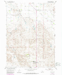
1954 Map of Bartlett
USGS Topo · Published 1985About this map
Bartlett serves as the primary hub of this Wheeler County landscape, established near the junction of Range 10 West and Range 11 West. The map reveals a rural economy shaped by the drainage of Beaver Creek and the expansive Buffalo Flats, where windmills and a Flowing Well point to the critical importance of water management in the Nebraska Sandhills. In the southern portion of the sheet, the village infrastructure includes a Church, the Bartlett Cemetery, and a prominent Water Tank. To the north, the small settlement of Cumminsville sits along the section lines, representing the dispersed nature of early High Plains communities. This document, based on 1950s field checks with 1980s photorevisions, preserves the specific placement of farmsteads and rural roads before the consolidation of modern land use.
Find a feature on this map
10 named features on this map. Tap any name to fly to it.
Don’t see what you’re looking for? This feature index may not catch every label — zoom into the map to look around manually.
Map Details
Editions of this 1954 Bartlett Map
2 editions found
Other maps of this area

1954 · Bartlett NW
USGS Topo · 1:24,000

1954 · Bartlett SE
USGS Topo · 1:24,000

1954 · Bartlett
USGS Topo · 1:24,000

1954 · Ericson
USGS Topo · 1:24,000

1955 · Broken Bow
USGS Topo · 1:250,000

1955 · O'Neill
USGS Topo · 1:250,000

1956 · Broken Bow
USGS Topo · 1:250,000

1959 · O'Neill
USGS Topo · 1:250,000

1960 · Spalding 2 SW
USGS Topo · 1:24,000

1960 · Spalding 2 NW
USGS Topo · 1:24,000