
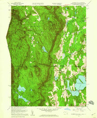
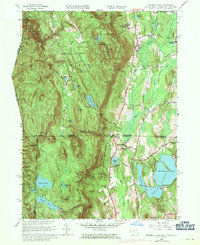
1958 Map of Bash Bish Falls
USGS Topo · Published 1990About this map
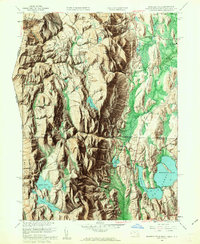
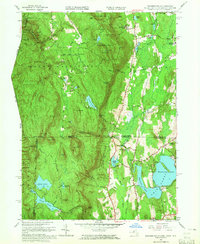
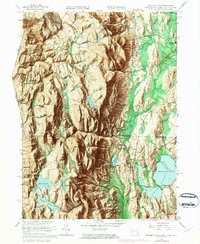
The dramatic terrain of the Berkshire Hills dominates this landscape where Massachusetts, Connecticut, and New York meet. High elevations like Mount Everett Reservation and Mt Race overlook a network of trails, including a significant stretch of the Appalachian Trail as it traverses Sages Ravine and Bear Mountain. The hydrology of the area is particularly complex, featuring high-altitude ponds such as Guilder Pond and Plantain Pond that feed into the celebrated Bash Bish Falls to the west.
Find a feature on this map
90 named features on this map. Tap any name to fly to it.
Don’t see what you’re looking for? This feature index may not catch every label — zoom into the map to look around manually.
Map Details
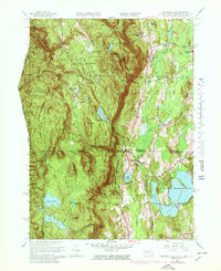
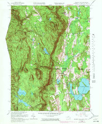
Editions of this 1958 Bash Bish Falls Map
8 editions found
Historical Maps of Salisbury Through Time
226 maps found

1885 Sheffield
Berkshire County, MA

1886 Becket
Berkshire County, MA

1886 Greylock
Berkshire County, MA

1888 Becket
Berkshire County, MA

1888 Sandisfield
Berkshire County, MA

1888 Sheffield
Berkshire County, MA

1890 Berlin
Berkshire County, MA

1891 Greylock
Berkshire County, MA

1891 Sheffield
Berkshire County, MA

1893 Becket
Berkshire County, MA

1893 Greylock
Berkshire County, MA

1893 Sheffield
Berkshire County, MA

1894 Berlin
Berkshire County, MA

1897 Becket
Berkshire County, MA

1897 Sheffield
Berkshire County, MA

1898 Greylock
Berkshire County, MA

1944 Cheshire
Berkshire County, MA

1944 Hancock
Berkshire County, MA

1944 Pittsfield East
Berkshire County, MA

1944 Pittsfield West
Berkshire County, MA

1944 Williamstown
Berkshire County, MA

1944 Windsor
Berkshire County, MA

1945 Becket
Berkshire County, MA

1945 East Lee
Berkshire County, MA

1945 Peru
Berkshire County, MA

1946 Cheshire
Berkshire County, MA

1946 Great Barrington
Berkshire County, MA

1946 Monterey
Berkshire County, MA

1946 Otis
Berkshire County, MA

1946 Pittsfield West
Berkshire County, MA

1946 South Sandisfield
Berkshire County, MA

1946 Williamstown
Berkshire County, MA

1946 Windsor
Berkshire County, MA

1947 Cheshire
Berkshire County, MA

1947 Pittsfield East
Berkshire County, MA

1947 Pittsfield West
Berkshire County, MA

1947 Williamstown
Berkshire County, MA

1947 Windsor
Berkshire County, MA

1948 Ashley Falls
Berkshire County, MA

1948 Bashbish Falls
Berkshire County, MA

1948 Becket
Berkshire County, MA

1948 East Lee
Berkshire County, MA

1948 Egremont
Berkshire County, MA

1948 Great Barrington
Berkshire County, MA

1948 Hancock
Berkshire County, MA

1948 Monterey
Berkshire County, MA

1948 Otis
Berkshire County, MA

1948 Peru
Berkshire County, MA

1948 South Sandisfield
Berkshire County, MA

1948 Stockbridge
Berkshire County, MA

1948 Tolland
Berkshire County, MA

1949 Ashley Falls
Berkshire County, MA

1949 Bashbish Falls
Berkshire County, MA

1950 East Lee
Berkshire County, MA

1950 Egremont
Berkshire County, MA

1954 Becket
Berkshire County, MA

1954 Tolland
Berkshire County, MA

1958 Ashley Falls
Berkshire County, MA
1958 Bash Bish Falls
Berkshire County, MA

1958 Becket
Berkshire County, MA

1958 East Lee
Berkshire County, MA

1958 Egremont
Berkshire County, MA

1958 Great Barrington
Berkshire County, MA

1958 Monterey
Berkshire County, MA

1958 Otis
Berkshire County, MA

1958 South Sandisfield
Berkshire County, MA

1958 Tolland Center
Berkshire County, MA

1959 Cheshire
Berkshire County, MA

1959 Peru
Berkshire County, MA

1959 Pittsfield East
Berkshire County, MA

1959 Pittsfield West
Berkshire County, MA

1959 Stockbridge
Berkshire County, MA

1960 Hancock
Berkshire County, MA

1960 Williamstown
Berkshire County, MA

1960 Windsor
Berkshire County, MA

1973 Becket
Berkshire County, MA

1973 Cheshire
Berkshire County, MA

1973 East Lee
Berkshire County, MA

1973 Egremont
Berkshire County, MA

1973 Great Barrington
Berkshire County, MA

1973 Hancock
Berkshire County, MA

1973 Monterey
Berkshire County, MA

1973 Otis
Berkshire County, MA

1973 Peru
Berkshire County, MA

1973 Pittsfield East
Berkshire County, MA

1973 Pittsfield West
Berkshire County, MA

1973 Stockbridge
Berkshire County, MA

1973 Williamstown
Berkshire County, MA

1973 Windsor
Berkshire County, MA

1975 Ashley Falls
Berkshire County, MA

1975 Bashbish Falls
Berkshire County, MA

1975 Becket
Berkshire County, MA

1975 Cheshire
Berkshire County, MA

1975 East Lee
Berkshire County, MA

1975 Egremont
Berkshire County, MA

1975 Great Barrington
Berkshire County, MA

1975 Hancock
Berkshire County, MA

1975 Monterey
Berkshire County, MA

1975 Otis
Berkshire County, MA

1975 Peru
Berkshire County, MA

1975 Pittsfield East
Berkshire County, MA

1975 Pittsfield West
Berkshire County, MA

1975 South Sandisfield
Berkshire County, MA

1975 State Line
Berkshire County, MA

1975 Stockbridge
Berkshire County, MA

1975 Tolland Center
Berkshire County, MA

1975 Williamstown
Berkshire County, MA

1975 Windsor
Berkshire County, MA

1987 Ashley Falls
Berkshire County, MA

1987 East Lee
Berkshire County, MA

1987 Great Barrington
Berkshire County, MA

1987 Otis
Berkshire County, MA

1987 Stockbridge
Berkshire County, MA

1987 Tolland Center
Berkshire County, MA

1988 Cheshire
Berkshire County, MA

1988 Pittsfield East
Berkshire County, MA

1988 Pittsfield West
Berkshire County, MA

1997 Ashley Falls
Berkshire County, MA

1997 East Lee
Berkshire County, MA

1997 Great Barrington
Berkshire County, MA

1997 Otis
Berkshire County, MA

1997 Pittsfield East
Berkshire County, MA

1997 Stockbridge
Berkshire County, MA

1997 Tolland Center
Berkshire County, MA

1997 Williamstown
Berkshire County, MA

1998 Cheshire
Berkshire County, MA

1998 Pittsfield West
Berkshire County, MA

2010 Egremont
Berkshire County, MA

2010 Pittsfield West
Berkshire County, MA

2011 State Line
Berkshire County, MA

2012 Ashley Falls
Berkshire County, MA

2012 Bash Bish Falls
Berkshire County, MA

2012 Becket
Berkshire County, MA

2012 Cheshire
Berkshire County, MA

2012 East Lee
Berkshire County, MA

2012 Egremont
Berkshire County, MA

2012 Great Barrington
Berkshire County, MA

2012 Hancock
Berkshire County, MA

2012 Monterey
Berkshire County, MA

2012 Otis
Berkshire County, MA

2012 Peru
Berkshire County, MA

2012 Pittsfield East
Berkshire County, MA

2012 Pittsfield West
Berkshire County, MA

2012 South Sandisfield
Berkshire County, MA

2012 State Line
Berkshire County, MA

2012 Stockbridge
Berkshire County, MA

2012 Tolland Center
Berkshire County, MA

2012 Williamstown
Berkshire County, MA

2012 Windsor
Berkshire County, MA

2015 Ashley Falls
Berkshire County, MA

2015 Bash Bish Falls
Berkshire County, MA

2015 Becket
Berkshire County, MA

2015 Cheshire
Berkshire County, MA

2015 East Lee
Berkshire County, MA

2015 Egremont
Berkshire County, MA

2015 Great Barrington
Berkshire County, MA

2015 Hancock
Berkshire County, MA

2015 Monterey
Berkshire County, MA

2015 Otis
Berkshire County, MA

2015 Peru
Berkshire County, MA

2015 Pittsfield East
Berkshire County, MA

2015 Pittsfield West
Berkshire County, MA

2015 South Sandisfield
Berkshire County, MA

2015 State Line
Berkshire County, MA

2015 Stockbridge
Berkshire County, MA

2015 Tolland Center
Berkshire County, MA

2015 Williamstown
Berkshire County, MA

2015 Windsor
Berkshire County, MA

2018 Ashley Falls
Berkshire County, MA

2018 Bash Bish Falls
Berkshire County, MA

2018 Becket
Berkshire County, MA

2018 Cheshire
Berkshire County, MA

2018 East Lee
Berkshire County, MA

2018 Egremont
Berkshire County, MA

2018 Great Barrington
Berkshire County, MA

2018 Hancock
Berkshire County, MA

2018 Monterey
Berkshire County, MA

2018 Otis
Berkshire County, MA

2018 Peru
Berkshire County, MA

2018 Pittsfield East
Berkshire County, MA

2018 Pittsfield West
Berkshire County, MA

2018 South Sandisfield
Berkshire County, MA

2018 State Line
Berkshire County, MA

2018 Stockbridge
Berkshire County, MA

2018 Tolland Center
Berkshire County, MA

2018 Williamstown
Berkshire County, MA

2018 Windsor
Berkshire County, MA

2021 Ashley Falls
Berkshire County, MA

2021 Bash Bish Falls
Berkshire County, MA

2021 Becket
Berkshire County, MA

2021 Cheshire
Berkshire County, MA

2021 East Lee
Berkshire County, MA

2021 Egremont
Berkshire County, MA

2021 Great Barrington
Berkshire County, MA

2021 Hancock
Berkshire County, MA

2021 Monterey
Berkshire County, MA

2021 Otis
Berkshire County, MA

2021 Peru
Berkshire County, MA

2021 Pittsfield East
Berkshire County, MA

2021 Pittsfield West
Berkshire County, MA

2021 South Sandisfield
Berkshire County, MA

2021 State Line
Berkshire County, MA

2021 Stockbridge
Berkshire County, MA

2021 Tolland Center
Berkshire County, MA

2021 Williamstown
Berkshire County, MA

2021 Windsor
Berkshire County, MA

2023 Great Barrington
Berkshire County, MA

2024 Ashley Falls
Berkshire County, MA

2024 Bash Bish Falls
Berkshire County, MA

2024 Becket
Berkshire County, MA

2024 Cheshire
Berkshire County, MA

2024 East Lee
Berkshire County, MA

2024 Egremont
Berkshire County, MA

2024 Great Barrington
Berkshire County, MA

2024 Hancock
Berkshire County, MA

2024 Monterey
Berkshire County, MA

2024 Otis
Berkshire County, MA

2024 Peru
Berkshire County, MA

2024 Pittsfield East
Berkshire County, MA

2024 Pittsfield West
Berkshire County, MA

2024 South Sandisfield
Berkshire County, MA

2024 State Line
Berkshire County, MA

2024 Stockbridge
Berkshire County, MA

2024 Tolland Center
Berkshire County, MA

2024 Williamstown
Berkshire County, MA

2024 Windsor
Berkshire County, MA