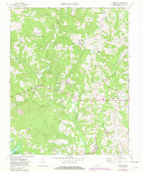
1968 Map of Baskerville
USGS Topo · Published 1981About this map
The community of Baskerville serves as a central point in this late 1960s portrait of Mecklenburg County, where the Norfolk and Danville railroad line cuts an east-west path through the landscape. This era shows a rural network punctuated by numerous crossroads settlements such as Antlers, Midway, and Stony Cross, the latter notable for its proximity to State Prison Camp No 4. The map reveals a deeply religious landscape defined by several family and community landmarks, including St Andrews Ch and Union Hill Ch. To the south, the terrain transitions into the Elm Hill State Game Management Area, situated along the northern reaches of the John H Kerr Reservoir. The presence of several Mines and Quarries indicates a local economy still tied to the extraction of mineral resources from the rolling hills of southern Virginia.
Find a feature on this map
41 named features on this map. Tap any name to fly to it.
Don’t see what you’re looking for? This feature index may not catch every label — zoom into the map to look around manually.
Map Details
Editions of this 1968 Baskerville Map
4 editions found
Other maps of this area

1953 · Greensboro
USGS Topo · 1:250,000

1954 · Greensboro
USGS Topo · 1:250,000

1955 · Chase City
USGS Topo · 1:62,500

1955 · Kenbridge
USGS Topo · 1:62,500

1955 · Boydton
USGS Topo · 1:62,500

1962 · Greensboro
USGS Topo · 1:250,000

1966 · Greensboro
USGS Topo · 1:250,000
1966 · Wightman
USGS Topo · 1:24,000
1966 · North View
USGS Topo · 1:24,000
1966 · Chase City
USGS Topo · 1:24,000