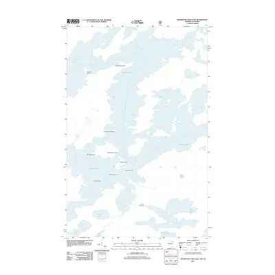
2011 Map of Basswood Lake East
USGS Topo · Published 2011About this map
Basswood Lake dominates this borderland landscape, where an intricate network of waterways and islands defines the geography of the northern frontier. This 2011 survey illustrates the complex aquatic environment along the international boundary, characterized by named landforms such as United States Point and a series of prominent islands including Washington Island, Lincoln Island, and the notably named Indian Grave Island. To the south, smaller water bodies like Wind Lake, Indiana Lake, and Washte Lake are connected through the wilderness terrain. The presence of the Wind Lake Dam indicates water management within this lakeland system, while numerous smaller islands like Squirrel Island and Norway Island pepper the expanses of the primary lake. The map serves as a detailed guide to the hydrography of the region, from the larger basins to secluded spots like Acorn Lake and Hula Lake.
Find a feature on this map
17 named features on this map. Tap any name to fly to it.
Don’t see what you’re looking for? This feature index may not catch every label — zoom into the map to look around manually.
Map Details
Editions of this 2011 Basswood Lake East Map
This is the sole edition of this map. No revisions or reprints were ever made.
Other maps of this area

1954 · Two Harbors
USGS Topo · 1:250,000

1957 · Two Harbors
USGS Topo · 1:250,000

1957 · Gabbro Lake
USGS Topo · 1:62,500

1957 · Ensign Lake
USGS Topo · 1:62,500

1957 · Basswood Lake
USGS Topo · 1:62,500

1957 · Quetico
USGS Topo · 1:250,000

1958 · Two Harbors
USGS Topo · 1:250,000

1964 · Two Harbors
USGS Topo · 1:250,000

1968 · Quetico
USGS Topo · 1:250,000
1976 · Basswood Lake SW
USGS Topo · 1:24,000