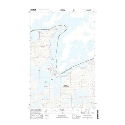
2016 Map of Basswood Lake East
USGS Topo · Published 2016About this map
Basswood Lake dominates this international boundary landscape where the waters of northern Minnesota meet Ontario. This 2016 survey highlights a complex network of glacial islands and sheltered bays within the Superior National Forest. The map documents the intricate shoreline of Wind Bay and Hoist Bay, along with smaller interior water bodies like Indiana Lake, Good Lake, and Wind Lake.
Find a feature on this map
27 named features on this map. Tap any name to fly to it.
Don’t see what you’re looking for? This feature index may not catch every label — zoom into the map to look around manually.
Map Details
Editions of this 2016 Basswood Lake East Map
This is the sole edition of this map. No revisions or reprints were ever made.
Other maps of this area

1954 · Two Harbors
USGS Topo · 1:250,000

1957 · Two Harbors
USGS Topo · 1:250,000

1957 · Gabbro Lake
USGS Topo · 1:62,500

1957 · Ensign Lake
USGS Topo · 1:62,500

1957 · Basswood Lake
USGS Topo · 1:62,500

1957 · Quetico
USGS Topo · 1:250,000

1958 · Two Harbors
USGS Topo · 1:250,000

1964 · Two Harbors
USGS Topo · 1:250,000

1968 · Quetico
USGS Topo · 1:250,000
1976 · Basswood Lake SW
USGS Topo · 1:24,000