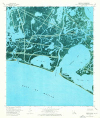
1973 Map of Bastian Bay
USGS Topo · Published 1976About this map
West Bastian Bay Oil and Gas Field dominates the hydraulic landscape of this Plaquemines Parish coastal area, where industrial engineering intersects with the delta's marshy reaches. The complex network of dredged waterways and artificial cuts is evident in the straight lines of Meyers Canal and numerous pipelines that cross natural features like Huertes Bayou and Bayou Grand. This orthophotomap transition reveals how the mid-century energy industry reshaped the barrier island and back-bay environment. Landmarks such as the Pumping Station near Chaland Bay and various offshore platforms indicate the active extraction economy of the 1970s. Along the Gulf of Mexico, fragile landforms like Bastian Island and Lanaux Island guard the entrance to Bastian Bay and Bay Joe Wise, showing the dynamic state of the Louisiana shoreline before decades of further coastal change.
Find a feature on this map
34 named features on this map. Tap any name to fly to it.
Don’t see what you’re looking for? This feature index may not catch every label — zoom into the map to look around manually.
Map Details
Editions of this 1973 Bastian Bay Map
2 editions found
Other maps of this area

1892 · Quarantine
USGS Topo · 1:62,500

1893 · Fort Livingston
USGS Topo · 1:62,500

1935 · Port Sulphur
USGS Topo · 1:31,680

1935 · Bastian Bay
USGS Topo · 1:31,680

1935 · Bay Ronquille
USGS Topo · 1:31,680

1935 · Tropical Bend
USGS Topo · 1:31,680

1941 · Empire
USGS Topo · 1:62,500

1944 · Empire
USGS Topo · 1:62,500

1947 · Buras
USGS Topo · 1:31,680

1947 · Bay Ronquille
USGS Topo · 1:31,680